How to use the geolocation tools
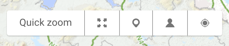
logainm.ie has made a number of geolocation facilities available as part of the interactive maps on the public website. These facilities can be found in the toolbar located at the bottom of each map, beside the ‘Quick zoom’ button. Geolocation facilities allow users to discover and understand placenames in the context of the user’s immediate physical environment. To use these facilities, your device needs to have geolocation data enabled and you need to use a modern web browser. The geolocation facilities on logainm.ie are described below and some information is provided as regards enabling geolocation services on your device.
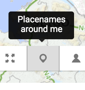
Placenames around me
Click or press the pin icon in the map toolbar to access this facility. logainm.ie will get your current physical location and return a list of placenames from the Placenames Database of Ireland that are within close proximity. Up to 500 results will be listed in order of proximity, with those locations closest to you listed first, within a radius of 3,000 metres. A yellow spot on the map represents your current location, based on the data obtained from your device. This facility enables users to learn about the placenames present in their immediate physical environment.
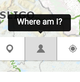
Where am I?
Click or press the person icon in the map toolbar to access this facility. logainm.ie will display your physical location in the context of the current map. A yellow spot on the map represents your current location, based on the data obtained from your device. This facility is useful if you wish to understand the physical setting of a particular placename or placenames in relation to your own current location.
Devices and common issues
In order to make use of the aforementioned tools you must enable geolocation data on the device you are using. Most modern mobile devices, such as smart phones or tablets, have access to global positioning system (GPS) data or to geolocation data obtained from your mobile network. Desktop and laptop computers sometimes have access to geolocation data through WiFi and intranet networks but this is not always the case. When geolocation data are unavailable an error message is displayed on the logainm.ie map: ‘Your location could not be detected.’ This message may also be displayed if geolocation services are disabled on the user device. You are advised to check your device settings and to enable geolocation services if necessary.
Geolocation facilities on logainm.ie also require the use of a modern web browser. Versions of Mozilla Firefox, Google Chrome or Microsoft Edge released in 2015 or later should work without issue. If a browser is unable to interact with the geolocation facilities on logainm.ie the relevant buttons and controls are hidden from the user interface. Your browser may request that you grant permission to logainm.ie to access your geolocation data. If you do not grant this permission an error message will be displayed: ‘Please allow the use of location services.’ Communication between your device and the logainm.ie website is encrypted and your location data is not recorded or stored.
Note: If you use the Android operating system and you are having issues with the geolocation tools, it may be helpful to switch the device’s geolocation mode from ‘Device only’ (GPS only) to ‘High accuracy’ (GPS, Wi-Fi, Bluetooth, GSM etc.).
Note: If you use the Safari browser on the Mac OS and you are having issues with the geolocation tools, it is recommended that you check your device’s settings and ensure that Safari is enabled under the ‘Location Services’ tab.
Accuracy
The accuracy of coordinates obtained from user devices depends on a number of factors: device type, number of nearby wireless networks, data sources (GPS or otherwise) etc. It is recommended that you try the geolocation facilities more than once in any one location as the results returned may not be identical every time.